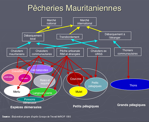
Fisheries Fisheries
Mauritania benefits a sea shore long of 750 km. In addition, the national territorial waters (200 miles marine) are thought to be one of the richest fish habitats in the world.
Resources
- Huge diversity of species
- High commercial value (70 species exported)
- Potentiel annual capture 1.5 to 1.7 million tons
- Demersal” resources: enough (octopus)
- Pelagique”resources: important potential, possibility of control development / shared stock
- Capture around 850 000 tm / year
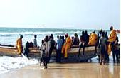
- Industrial fishing 48%
- Non- industrial fishing 52%
Rank in the Economy
- 40% of gains in foreign currency (2nd after mining )
- 20 to 25% of State Budgetary gains
- 4 to 6% of GDP
- 30 000 jobs representing 36% of jobs in the modern sector
- Consumption 3.44 kg / p / year
- Exportation 95% of captures. Only 10% of exported products under-go home processing.
- 60 factories designated for exportation to EU.
Fisheries policy of 1998 renewed in 2001
- Permanent Management of resources
- Enhanced Economy Integration
- Reinforcement of institutional capacity
- Environmental Preservation and maritime security
An encouraging institutional frame
- « Guichet unique » for investors at the Ministry of Economy and Industry
- Training Center targeting the needs of different fields (ENEMP, PDPAS, FST …)
- Research Institute
- Fisheries monotoring
- Quality analyzing laboratory (NDB & NKC)
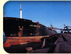
Existing Infrastructure
Nouadhibou
- Autonomous Port (industrial fisheries)
- Port of Tanit
- 30 factories for products processing to be exported to EU
- International Airport
Nouakchott
- The Fish Market of Nouakchott
- 30 factories of products processing for export to EU
- International Airport
- Autonomous Port of Nouak
Needs
- Development of non industrial and coastal fisheries
- Infrastructures development for unloading caches
- Improvement of processing, value added captures (development
of technical partnership & lsaquo; new products›
and trade & lsaquo; distribution, norms, quality)
Today our economic exchange with Japan in this foremost field is amounted yearly to 150,000,000 to 200,000,000 US$.
Mining Sector
Mauritanian under-ground contains important and varieties of mining resources and the most significant ones are:
Iron ore
Mauritania has an important veins of a big quantity of iron
ore (estimated to 250 000 000 tons); discovered in the ridge
of Rguibat, north of the country at the beginning of 20th
century and had been exploited since 1963. The multi-national
firm, the MIFERMA who assured the exploitation and export
of Mauritanian iron ore to Europe, USA and Japan has been
nationalized in 1974 and renamed since then the SNIM (Société
Nationale Industrielle et Minière), which is
in charge of crushing iron ore as well as its transport on
700km of railway to reach the mineral port of Nouadhibou for
exportation.
 The annual average of export in ton is about 13 million of tons; this ranks Mauritania as the 12th iron ore exporter in the world.
The operation of extraction, processing of iron ore to semi-finished products is done by SNIM. This has lead to important results for the national economy in terms of employment and income in foreign currencies. The annual average of export in ton is about 13 million of tons; this ranks Mauritania as the 12th iron ore exporter in the world.
The operation of extraction, processing of iron ore to semi-finished products is done by SNIM. This has lead to important results for the national economy in terms of employment and income in foreign currencies.
Copper
Mauritania has enormous potentials for copper in the Guelb
Mougreine near Akjoujt in the north of the country and in
the Mauritanides. This vein has been evaluated to 550
000 tons of copper in 8 million of tons of mineral oxide.
The copper extraction had been given to SOMIMA. Though, the
exploitation stopped for some couple years, it is expected
to resume before the end of this year .On the other hand,
the Hispano-Canadian company: Rio Narcea Gold Mines has started
to build up its gold plant at TASIAST in the north of the
country. The production of gold
has started in 2007 for about 4 tons / year. We
recall here that the copper oxide processing from 1989 to
1995 had led to produce 5 tons of gold.
Mauritanian underground contains very important other potential resources:
- Phosphates
- Rare earth
- Salt
- Gypsum north of Nouakchott
- Zinc
- lead
- Etc…
Some fresh prospecting results have proved the existence
of diamond, gold, chromium,uranium etc. In the eastern regions,
several foreign companies are nowadays prospecting after earning
and signing contracts with Mauritanian government.
Oil (Hydrocarbons)
Petroleum Exploration Opportunities 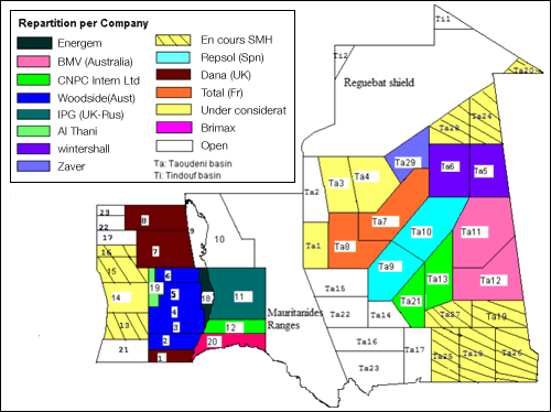
The aim of this article is to present the current status
of exploration in the Islamic Republic of Mauritania and to
highlight the petroleum potential of the virtually unexplored
onshore Mauritanian basins. A regional Petroleum evaluation
of the petroleum potential of the Mauritanian basins (Coastal
and Taoudeni basins) was carried out by BEICIP-FRANLAB in
1980. A second evaluation of the coastal basin was carried
out in 1985. The two studies were performed for the Ministry
of Mines and Industry with World Bank financing. The information
given below is taken from these studies updated with the results
of exploration performed between 1985 and 2001, and is complemented
by information of the legal and contractual framework. Mauritania
comprises 4 large geographical/geological units: The intracratonic
Taoudeni basin covering half of the country and opening eastward
into Mali, the coastal basin straddling the coastline and
extending southward over Senegal, the Reguibat Shield with
Precambrian and basement outcrops, the Mauritanides Range,
severely eroded, between the two basins:
The Mauritania Coastal Basin
The coastal basin extends from the northern to southern borders of the Mauritanian coastline over a distance of some 500 kilometres, and is over 300 kilometres wide from east to west. The coastal basin covers more than 160,000 km2, with 100,000 km2 of the basin being offshore.
Exploration History
- Exploration began in the coastal basin in 1960. Since then, only 40 wells have been drilled, all between 1968 until now. Table 1 details the exploration history. The seismic acquisition history is outlined in Table 2, and the drilling history in Table 3.
- Exploration has been steady, albeit slow, since 1966, with a brief period of non-exploration between 1992 and 1997. Most exploration has been focussed on the outer shelf, with one near shore well, and three deepwater wells.
Seismic Surveys
Offshore, the seismic grid is dense between the coast and the 2000 metre bathymetric contour. Conversely, onshore coverage is sparse, comprising only two reconnaissance surveys totalling only 1005 kilometres in the southern part of the country.
A total of 69,000 kilometres of 2D data and more than 1 8,500 km2 of 3D data have been acquired offshore since 1966. The quality of modern seismic data is generally quite good, with the recent Woodside JV acquired data (10,500 kilometres of 2D data and approximately 6000 sqkm of 3D data) highlighting the potential data quality that can be achieved offshore. In 2001, Veritas obtained the first speculative seismic acquisition survey of approximately 4333km 2D.
A database of most of this seismic data is available from the Department of Mines & Geology, including reprocessed lines from several of 1980’s vintage surveys. This includes some 30,000 kilometres of seismic lines and associated location maps. The data acquired by the Woodside JV is currently confidential and is hence unavailable.
Mauritanian government has signed an agreement on june ,
2003 , with TOTAL allowing him to proceed prospecting for
oil in the Taoudeni Basin (onshore)in Mauritanian desert.
Wells
Seven different operators have acquired 24 wells distributed unevenly throughout the offshore sector. Most wells targeted the CretaceousøTertiary post rift section. The deepest stratigraphic test is the Loup de Mer-1 well: the Neocomian carbonate bank being the primary objective. Most of the remaining wells targeted CretaceousøTertiary sandstone reservoirs. The syn-rift and early post-rift section remains untested in the coastal basin.
7 of the 17 wells, six failed due to lack of reservoir, with the objectives being in a midøupper slope setting. Most were drilled before the modern understanding of deepwater depositional systems. Nonetheless, V-1 recovered some seven litres of oil from thin Maastrichtian sandstones, while significant shows were also recorded from the nearby Coppolani-1 well.
Four of the thirteen wells intersected extremely sand-prone systems with trap integrity posing the greatest reason for failure. Autruche-1 was probably drilled too far down-dip from the bounding fault in a tilted fault block, although attic reserves are likely to be marginal at best. All four wells recorded oil shows.
Ras el Baida-1 targeted a deepwater Senonian fan delta, and recorded oil shows. The fan delta was extremely sand-prone.
The oil production in the country has started since February 2006 for about 75,000 barrel per day.
( Table ref : Exploration History of the Mauritania Coastal Basin )
Hydrocarbon Shows
There are several recorded hydrocarbon shows offshore of Mauritania. Most important of these are the discovery of Chinguetti-1 and the V-1 oil recovery from thin Maastrichtian deepwater sands. The V-1 well also intersected an early oil mature Turonian source interval from 3500m.
Coppolani-1 recovered oil during circulation whilst drilling the Maastrichtian–Campanian, but there were no economically important reservoirs at this level. OCT-1B also recorded oil shows through the Late Cretaceous.
V-1, OCT-1B and Coppolani-1 may have been charged from Cretaceous marine source rocks.
Autruche-1 recovered oil shows from the Aptian–Albian, including an interpreted hydrocarbon column in well logs. There does there not appear to be any Mid-Cretaceous marine source rocks in the Autruche-1 area. An alternative source may exist in the Jurassic or Early Cretaceous.
Ras el Baida-1 also recorded oil shows from the Lower Tertiary. The origin of these oils is unknown.
( Table ref : Seismic Acquisition History of the Mauritania Coastal Basin )
( Table ref : Drilling history of the Mauritania Coastal Basin )
Farming
The agro-pastoral sector is the largest employer in the country, accounting for48% of jobs. It accounts for approximately 20% of GDP.
Agricultural sector
Agriculture in Mauritania is characterized by duality: there are
two separate and distinct farming areas, the Senegal River Valley and
the so-called wet zones further to the north. The types and forms of
agriculture practiced in these areas are different. In the Valley and surrounding
dams the irrigated agriculture leads the production which is supported by industrial
and commercial groups, while in the rest of the country, self-subsistence farming is
dominant. Fertile land is limited, found primarily, along the Senegal River and around
inland oases. However, Mauritania’s potential agricultural area is still quite sizeable (400,000 hectares).
Products grown in Mauritania
Mauritania cultivates millet, sorghum, maize, rice, dates,
beans and several other vegetable varieties. However; the
need in cereals suffers a shortage, therefore the country
imports around 250 000 to 300 000tons of cereals annually,
compared to domestic products : 122 000 tons. On the other
hand, the foreign company GDM( Grands Domaines de Mauritanie)
has started since it campaign 2000-2001 to export some products(green
beans , okra, pepper ,potato… ) from the Senegal River
Valley to EU market by air and sea via Nouakchott.
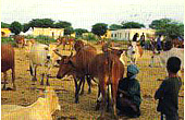
Livestock
Although livestock production is mainly traditional and transhumant,
it remains one of the pillars of the Mauritanian economy.
In Mauritania, livestock production is in most of cases a
range-type animal production but there has been a shift toward
other more intensive forms in the past few years. In 2001,
the national herd in Mauritania consisted of 1.5 million head
of cattle, 13 million sheep and goats and 1.3 million camels.
The creation of a milk collection /packing center located
in Nouakchott in these few years has helped to improve the
collection and processing of huge quantities of raw milk and
its derivative products ( camel cheese)that are widely
consummated in Mauritania 0,49kg/p/day, so about 95%
of domestic production goes to self-consumption.
The following investments are required to increase the supply of daily products
- Implementation of livestock fodder plants
- Development of crops used to manufacture fodder
- Development of forage crops
- Improvement of local breeds
- Other livestock products
- Leather and skins
- Poultry farming products
 Page Top Page Top |